India, a union of states, is a Sovereign, Secular, Democratic, Republic with a Parliamentary system of Government. Besides, The President is the constitutional head of the Executive of the Union. In the states, the Governor, as the representative of the President, is the head of the Executive. The system of government in states closely resembles that of the Union. Consequently, there are 28 states and 8 Union territories in the country. Moreover, Union Territories are administered by the President through an Administrator appointed by him/her. From the largest to the smallest, each State/UT of India has a unique demography, history, and culture, dress, festivals, language, etc. This section introduces you to the Indian States and the Union Territories in the Country and urges you to explore their magnificent uniqueness…
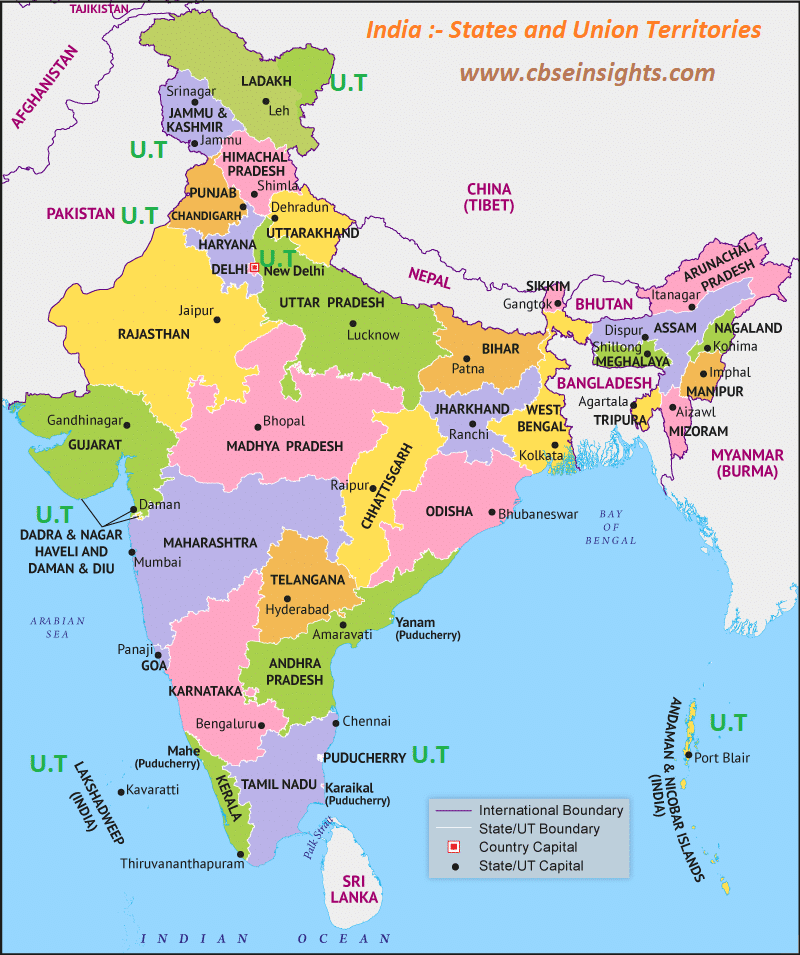
India comprises 28 States and 8 Union Territories. They are:
1)Andhra Pradesh,
2)Assam,
3)Arunachal Pradesh,
4)Bihar,
5)Chhattisgarh,
6)Goa,
7)Gujarat,
8)Haryana,
9)Himachal Pradesh,
10)Jharkhand,
11)Karnataka,
12)Kerala,
13)Madhya Pradesh,
14)Maharashtra,
15)Manipur,
16)Meghalaya,
17)Mizoram,
18)Nagaland,
19)Odisha,
20)Punjab,
21)Rajasthan,
22)Sikkim,
23)Tamil Nadu,
24)Telangana,
25)Tripura,
26)Uttarakhand,
27)Uttar Pradesh
28)West Bengal.
Union Territories of the Indian Union are:
1)Andaman and Nicobar Islands,
2)Chandigarh,
3)Dadra and Nagar Haveli and Daman and Diu,
4)National Capital Territory of Delhi,
5)Jammu and Kashmir,
6)Lakshadweep,
7)Ladakh
8)Puducherry.
India is one of the oldest civilizations in the world with a kaleidoscopic variety and rich cultural heritage and has achieved all-around socio-economic progress since Independence. As the 7th largest country in the world, India stands apart from the rest of Asia, marked off as it is by mountains and the sea, which give the country a distinct geographical entity. Bounded by the Great Himalayas in the north, it stretches southwards and at the Tropic of Cancer, tapers off into the Indian Ocean between the Bay of Bengal on the east and the Arabian Sea on the west.
Lying entirely in the northern hemisphere, the mainland extends between latitudes 8° 4′ and 37° 6′ north, longitudes 68° 7′ and 97° 25′ east and measures about 3,214 km from north to south between the extreme latitudes and about 2,933 km from east to west between the extreme longitudes. It has a land frontier of about 15,200 km. The total length of the coastline of the mainland, Lakshadweep Islands, and Andaman & Nicobar Islands are 7,516.6 km.
For the additional GK Topics :-