Q 1 – What are Lithospheric plates?
Ans – The lithosphere is broken into a number of plates known as the Lithospheric plates.
Q 2 – How do the Lithospheric plates move?
Ans – Lithospheric plates move because the molten magma moves inside the earth thereby the Lithospheric plates are moved very slowly just a few millimetres each year.
Q 3 – What is the result of movement of the Lithospheric plates?
Ans – The movement of these plates causes changes on the surface of the earth.
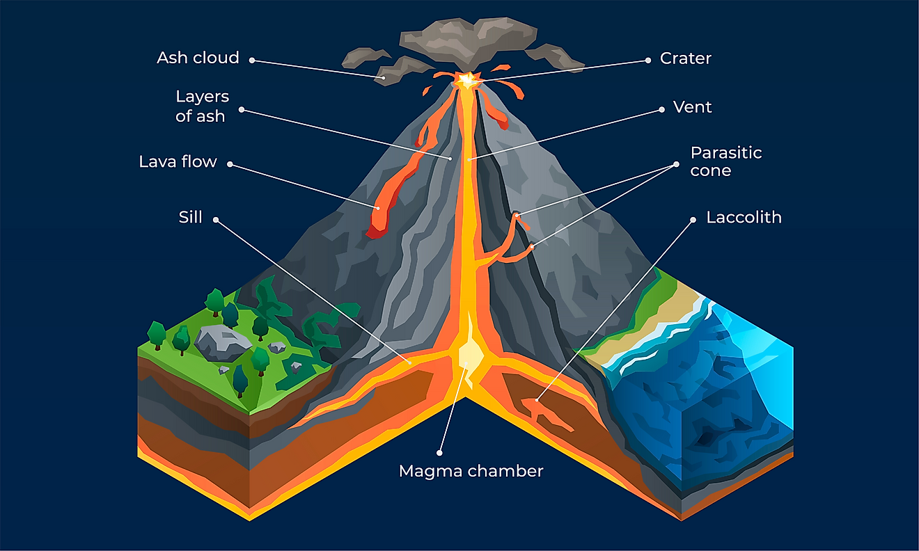
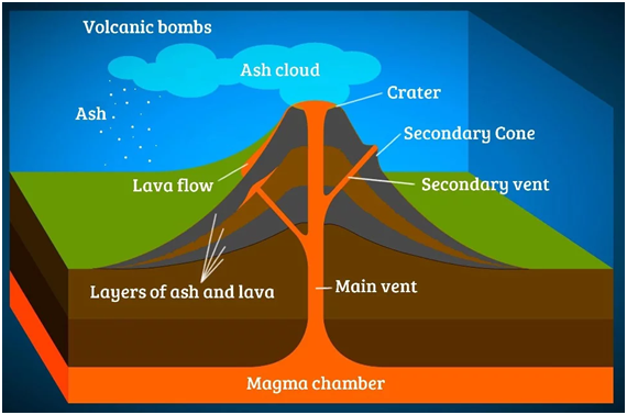
Q 4 – What is volcano?
Ans – A volcano is a vent (opening) in the earth’s crust through which molten material erupts suddenly.
Q 5 – What are distributaries?
Ans – As the river approaches the sea, the speed of the flowing water decreases and the river begins to break up into a number of streams called distributaries
Q 6 – How do the deltas form?
Ans – Each distributary forms its own mouth. The collection of sediments from all the mouths forms a delta.
Q 7– What are Glaciers?
Ans – Glaciers are rivers of ice.
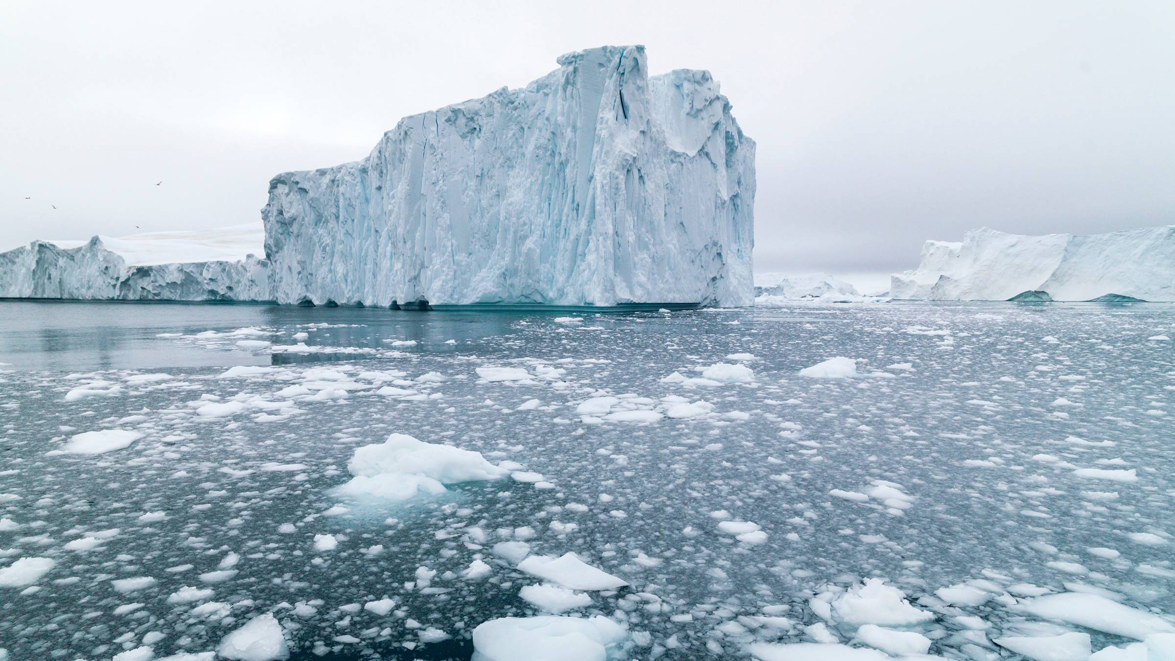
Q 8 – How are the glacial moraines formed?
Ans – The material carried by the glaciers, such as rocks, sand and silt gets deposited. These deposits form glacial moraines.
Q 9 – What do you understand about mushrooms rocks?
Ans – In the desert areas, wind makes rocks in the shape of a mushroom called mushroom rocks.
Q 10 – What do you understand about seismographs? Describe in brief.
Ans – An earthquake is measured with a machine called a seismograph. The magnitude of the earthquake is measured on the Richter scale. An earthquake of 2.0 or less can be felt only a little. When earthquake is measured over 5.0 on Richter scale, it can cause damage from falling things. A 6.0 or higher magnitude is considered very strong and 7.0 is classified as a major earthquake
Q 11 – What is called sand dunes loess?
Ans – In the desert areas, when the wind stops blowing, the sand falls and gets deposited in low hill like structures. These are called sand dunes. When the grains of sand is very fine and light, the wind can carry it over long distances, when such sand is deposited in large areas, it is called loess
Q 12 – How do the rivers erode the landscape?
Ans – The running water in the river erodes the landscape. Due to continuous erosion and deposition along the sides of the meander, the ends of the meander loop come closer and closer.
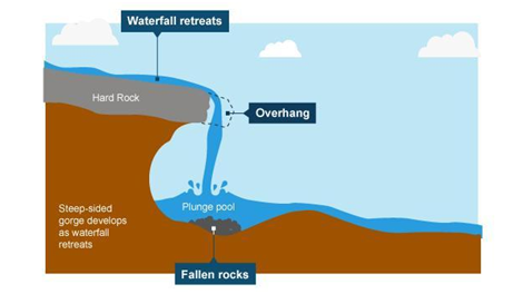
Q 13 – Write a short note on Waterfall.
Ans –The running water in the river erodes the landscape. When the river tumbles at a steep angle over very hard rocks or down a steep valley side it forms a waterfall. There are thousands of small waterfalls in the world. The highest waterfall is Angel Falls of Venezuela in South America. The other waterfalls are Niagara falls located on the border between Canada and the USA in North America and Victoria Falls on the borders of Zambia and Zimbabwe in Africa.
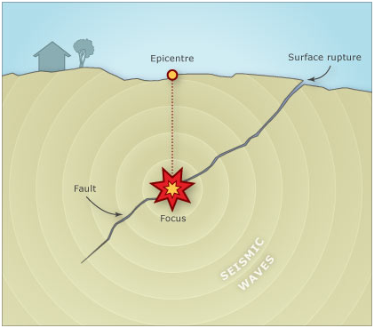
Q 14 – What are focus and epicentre?
Ans – The place in the crust where the movement starts is called the ‘focus’ and the place on the surface above the focus is called the ‘epicentre’. The greatest damage is usually closest to the epicentre and the strength of the earthquake decreases away from the centre.
Q 15 – How can the impact of earthquakes be minimized?
Ans – Although earthquakes cannot be predicted but the impact can be minimized. Selecting safe spots, staying away from fireplaces, chimneys etc., and be prepared are the measures which may be helpful as safeguards.
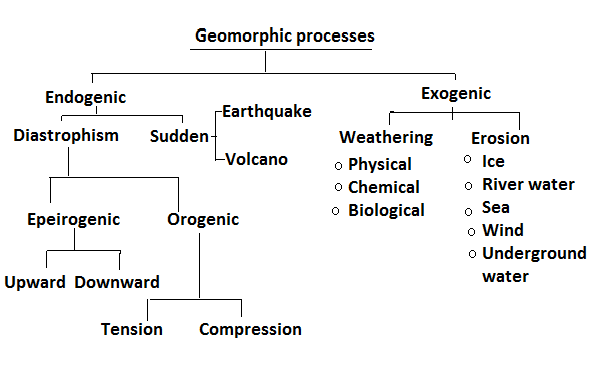
Q 16 – What do you understand about endogenic and exogenic forces?
Ans –The forces that act in the interior of the earth are called endogenic forces, while the forces that work on the surface of the earth are called exogenic forces. Endogenic forces sometimes produce sudden movements and at the other times produce slow movements. Sudden movements like earthquakes and volcanoes cause mass destruction over the surface of the earth.
Q 17 – Fill in the blanks:
- Magma inside the earth moves in a circular motion.
- A volcano is a vent in the earth’s crust through which molten material comes out
- The place in the crust where the earthquake starts is called epicentre
- The processes of erosion and deposition create different landform on the surface of earth.
- Deposition of layers of fine soil along the bank of rivers forms flood plains.
- Sand deposits over larger areas are called loess.
Q 18 – How can we minimise the impact of an earthquake?
Ans –
- Earthquakes cannot be predicted.
- Their impact can certainly be minimised if we are prepared before hand.
Q 19 – Define a volcano.
Ans – A volcano is a vent or a hole in the earth’s crust through which molten material erupts suddenly.
Q 20 –What are earthquakes? Define focus and epicentre
Ans – Earthquake:
- When the lithosphere plates move, the surface of the earth vibrates.
- The vibrations travel all around the earth.
- These vibrations are called earthquake.
Focus:
- The place or point in the crust where the movement starts is called Focus.
Epicentre:
- The place or the surface above the focus is called Epicentre
- Vibrations travel outwards from the epicentre as waves.
- Greatest damage occurs closest to the epicentre.
- The strength of the earthquake decreases, going away from the centre.
Q 21 –What are the three types of earthquake waves?
Ans – There are three types of earthquake waves:
- P waves or longitudinal.
- S waves or transverse waves.
- L waves or surface waves.
Q 22 – Give an account of some common earthquake prediction methods adopted locally by people.
Ans – Some of the common earthquake prediction methods adopted locally by people are:
- Wild animal behaviour.
- Agitated fish in the ponds.
- Snakes coming out to the surface from their holes.
- Animals trying to untie themselves and run away.
- Birds leaving their nests and beginning to chatter loudly.
- Aborigines beginning to run to higher grounds.
Q 23 – What is a seismograph? How is the magnitude of an earthquake measured?
Ans –
- An earthquake is measured with a machine.
- It is called a seismograph.
- The magnitude of the earthquake is measured on Richter scale.
- An earthquake of 2.0 or less is felt only a little.
- An earthquake over 5.0 causes damage from things falling.
- A 6.0 or higher magnitude is considered very strong and 7.0 is classified as a major earthquake.
Q 24 – What are the two processes which continuously wear away the landscape? Explain them.
Ans – The Processes:
The landscape is continuously worn away by two processes.
They are:
- Weathering and erosion.
- Weathering is the breaking up of rocks on the earth’s surface.
- Erosion is the wearing away of the landscape by different agents like water, wind and ice.
- The eroded material is carried away or transported by water, wind etc.
- They deposit material eventually.
- This process of erosion and deposition creates different landforms on the surface of the earth.
- Work of a River.
Q 25 – What is a waterfall? Explain with example.
Ans – When the rivers tumble at a steep angle over the hard rocks of a deep steep valley it forms a waterfall. For example Victoria waterfalls or Niagara waterfall.
Q 26 – Give an account of the work of wind.
Ans – Work pi Wind:
- An active agent of erosion and deposition in the deserts is wind.
- In deserts there are numerous rocks with a shape of a mushroom.
- They are commonly called mushroom rocks.
- Winds erode the lower section of the rock more than the upper part.
- Such rocks have narrower base and wider top.
- When the wind blows, it lifts and transports sand from one place to another.
- When it stops blowing, the sand falls and gets deposited in low hill like structures. These are called sand dunes.
- When the grains of sand are very fine and light, the wind carries it over very long distances.
- When such as and is deposited in large areas, they are called loess. Large deposits of loess are found in China.
Q 27 – What are the two types of the earth’s forces?
Ans –
- The earth’s movements are divided on the basis of the forces which cause them.
- The forces which act in the interior of the earth are called endogenic forces.
- The forces that work on the surface of the earth are called exogenic forces.
- Endogenic forces sometimes produce sudden movements.
- At other times they produce slow movements.
- Sudden movements are earthquakes and volcanoes.
- They cause mass destruction over the surface of the earth.
Q 28 –Write a true and false:
1. Sudden movements like earthquakes do not cause mass destruction. [False]
2. Deposition is the breaking up of rocks on the earth’s surface. [False]
3. Wearing away from the land by different agents like water, wind and ice is called erosion. [True]
4. Sea caves become bigger and only the roof remains to form the sea arches. [True]
5. Moraine is a depositional feature of glaciers. [True]
6. River is an agent of erosion and deposition in the desert. [False]
Q 29 – Match the contents of Column A with that of Column B.
| Column A | Column B |
| 1. Mushroom rock | (a) Zimbabwe and Zambia |
| 2. Meander | (b) Deserts |
| 3. Stacks | (c) S waves |
| 4. Glacier | (d) the Second course of the river |
| 5. victoria falls | (e) River of ice |
| 6. Transverse waves | (f) Sea waves |
Ans –
| Column A | Column B |
| 1.Mushroom rock | (b) Deserts |
| 2.Meander | (d) Second course of river |
| 3.Stacks | (f) Sea waves |
| 4.Glacier | (e) River of ice |
| 5.victoria falls | (a) Zimbabwe and Zambia |
| 6.Transverse waves | (c) S waves |