Shaping of the Earth’s Surface
Q 1 – Which of the following is an internal force that shapes the Earth’s surface?
A) Wind
B) Moving ice
C) Volcanic activity
D) Running water
C) Volcanic activity
Q 2 – Which geological event is described in the text as occurring suddenly and causing widespread damage?
A) Mountain formation
B) Valley cutting
C) Earthquake
D) Plateau creation
C) Earthquake
Q 3 – What is a primary benefit of understanding geological processes?
A) Stopping volcanic eruptions from happening
B) Preventing tectonic plates from moving
C) Helping people take precautions and prepare for natural disasters
D) Making the surface of the earth completely uniform
C) Helping people take precautions and prepare for natural disasters
Q 4 – The crust is relatively thicker beneath which of the following areas?
A) Ocean floors (15 kms)
B) Continents (30 kms )
C) Magma chambers (15-20 kms)
D) Outer core (1700 kms)
B) Continents (30 kms )
Q 5 – What is the core believed to be mainly composed of ?
A) Silica and aluminium
B) Silica and magnesium
C) Nickel and iron
D) Molten magma
C) Nickel and iron
Q 6 – Who originally proposed the idea of Continental Drift, which was later extended into the Theory of Plate Tectonics?
A) K.S. Valdiya
B) Alfred Wegener
C) Eurasian Plate
D) Asthenosphere
B) Alfred Wegener
Q 7 – Which Indian geologist provided strong scientific evidence supporting plate tectonics through studies of the Indian Plate and the Himalayas?
A) Alfred Wegener
B) K.S. Valdiya
C) Aryabhata
D) D.K. Bose
B) K.S. Valdiya
Q 8 – According to the text, tectonic plates fit together like a:
A) Continuous smooth sheet
B) Puzzle
C) Layer of bricks
D) Concentric ring
B) Puzzle
Q 9 – Which type of plate movement leads to the formation of new crust, volcanic activity, and rift valleys?
A) Convergent Movement
B) Transform Movement
C) Divergent Movement
D) Static Movement
C) Divergent Movement
Q 10 – The collision of tectonic plates moving toward each other is responsible for creating which mountain range mentioned in the text?
A) Andes
B) Himalayas
C) Alps
D) Rockies
B) Himalayas
Q 11 – Transform movement along plate boundaries mainly results in which type of natural hazard?
A) Deep oceanic trenches
B) Strong earthquakes
C) Volcanic mountain ranges
D) Formation of new crust
B) Strong earthquakes
Q 12 – What is a key characteristic of weathering that distinguishes it from other surface processes?
A) Rocks are carried long distances by wind.
B) Rocks are broken down in the same place where they are formed without transportation.
C) It only occurs deep inside the liquid inner core.
D) It is solely caused by human construction activities.
B) Rocks are broken down in the same place where they are formed without transportation.
Q 13 – Which type of weathering involves the breakdown of rocks into smaller pieces without changing their chemical composition?
A) Chemical weathering
B) Biological weathering
C) Physical or mechanical weathering
D) Organic weathering
C) Physical or mechanical weathering
Q 14 – Chemical weathering primarily occurs when minerals in rocks react with which of the following substances?
A) Plant roots and burrowing animals
B) Water, oxygen, or acids
C) High pressure and friction alone
D) Glaciers and running waves
B) Water, oxygen, or acids
Q 15 – What biological method is a cause for widening cracks in rocks?
A) Microorganisms changing chemical properties
B) Plant roots growing into cracks
C) Burrowing animals carrying rocks away
D) Human agricultural machinery
B) Plant roots growing into cracks
Q 16 – What is the key difference between weathering and erosion?
A) Weathering only happens near coastal regions.
B) Erosion does not involve any natural agents like water or wind.
C) Erosion involves the movement of rock particles from their original place, unlike weathering.
D) Weathering creates landforms over short distances while erosion takes millions of years.
C) Erosion involves the movement of rock particles from their original place, unlike weathering.
Q 17 – Which process involves no physical movement of rock material from its original location?
A) Erosion
B) Transportation
C) Weathering
D) Deposition
C) Weathering
Q 18 – In which part of their course do rivers flow with the greatest speed and energy to erode the land?
A) Lower course
B) Middle course
C) Floodplains
D) Upper course
D) Upper course
Q 19 – What happens to a river’s speed when it reaches flatter areas in its middle and lower courses and also name the feature formed at the Mouth of River ?
A) It increases rapidly.
B) It remains completely constant.
C) It decreases and begins to deposit materials which leads to Delta Formation.
D) It completely dries up immediately.
C) It decreases and begins to deposit materials which leads to Delta Formation.
Q 20 – What is the geological process called when moving sand particles carried by wind strike and wear down rocks?
A) Deposition
B) Abrasion
C) Meandering
D) Subduction
B) Abrasion
Q 21 – Why is wind erosion highly effective in dry and desert regions?
A) Dense forests trap the fast-moving wind currents.
B) Vegetation is sparse, leaving the dry ground largely exposed with little plant cover.
C) Frequent heavy rainfall turns the desert sand into dense mud blocks.
D) Massive glaciers push loose desert rocks down the steep sand slopes.
B) Vegetation is sparse, leaving the dry ground largely exposed with little plant cover.
Q 22 – What is the process called when moving glaciers pull out pieces of rock and freeze them into the ice?
A) Abrasion
B) Plucking
C) Deposition
D) Dissolution
B) Plucking
Q 23 – Which type of mountain is formed when rock layers between two colliding tectonic plates get compressed, bent, and folded?
A) Block Mountains
B) Volcanic Mountains
C) Fault Mountains
D) Fold Mountains
D) Fold Mountains
Q 24 – Plateaus are sometimes referred to as what structural feature due to their relatively level top surface?
A) Craters
B) Tablelands
C) Ridges
D) Cones
B) Tablelands
Q 25 – Deserts are dry regions that receive a very low amount of annual rainfall, usually less than:
A) 50 cm per year
B) 100 cm per year
C) 25 cm per year
D) 75 cm per year
C) 25 cm per year
Q 26 – Fill in the Blanks:
1.The surface of the earth is not uniform but varied and _______.
2. Internal forces like plate movements, earthquakes, and volcanic activity cause changes in the Earth’s ______.
3. External forces wear away the land through weathering and erosion, and then ______ materials in other places.
4. The three main layers of the Earth differ from one another in terms of composition, _______, and density.
5. The outermost layer of the Earth, on which we live, is called the _____.
6. Beneath the crust lies the mantle, which is made up of molten and semi-molten material called _______.
7. The heat generated in the core plays a significant role in driving __________ in the mantle.
8. The earth’s crust is not one continuous surface but is divided into several large and small pieces known as ___________.
9. The natural forces that carry out the leveling of the Earth’s surface are called ____________.
10. In transform movement, tectonic plates slide past each other in _____________.
11. An example of a transform boundary given in the text is the _____________ in the USA.
12. Plant roots widen cracks in rocks, while __________ loosen the soil and rock.
13. When the speed of the wind _________, it loses its carrying capacity and begins to drop the materials it was transporting.
14. Glaciers are described in the handwritten notes as rivers of _______ (or ice).
15. The scraping and grinding of the land beneath a moving glacier is a process known as _________.
16. While some landforms are worn down by external forces, others are built up through _________.
17. When molten material called magma reaches the Earth’s surface through cracks in the crust, it is called _________.
18.Tibetan Plateau that occur at very high elevations are often referred to as the _____________.
19. Glacial erosion transforms an originally narrow V-shaped valley into a broad___________.
20. A _________ is a shallow water body formed behind a spit or sandbar that is separated from the open sea.
1. uneven
2. crust
3. deposit
4. temperature
5. crust
6. magma
7. convection currents
8. tectonic plates
9. agents of gradation.
10. opposite directions
11. San Andreas Fault
12. burrowing animals
13. decreases
14. snow
15. abrasion
16. deposition
17. lava
18. Roof of the world
19. U-shaped valley
20.lagoon
Assertion and Reason Questions:
Directions:
- Choose A if both Assertion and Reason are true and Reason is the correct explanation of Assertion.
- Choose B if both Assertion and Reason are true but Reason is not the correct explanation of Assertion.
- Choose C if Assertion is true but Reason is false.
- Choose D if Assertion is false but Reason is true.
Q 27 – Assertion: Mountains, plateaus, and valleys take millions of years to develop.
Reason: Some geological changes take place very slowly over a long period of time.
A if both Assertion and Reason are true and Reason is the correct explanation of Assertion.
Q 28 – Assertion: Wind, water, and ice are classified as internal forces.
Reason: External forces operate outside the Earth to wear away and reshape the land.
D (Assertion is false because wind, water, and ice are external forces, but the Reason is a true statement).
Q 29 – Assertion: The entire core of the Earth is in a liquid state.
Reason: The core is subjected to extremely high temperatures and pressure.
D (Assertion is false because wind, water, and ice are external forces, but the Reason is a true statement).
Q 30 – Assertion: Convergent plate movement can lead to the formation of massive mountains like the Himalayas.
Reason: In convergent movement, tectonic plates move towards each other and collide.
A if both Assertion and Reason are true and Reason is the correct explanation of Assertion.
Q 31 – Assertion: Weathering and erosion are identical processes because both leave rock particles in their original position.
Reason: Erosion involves transporting weathered materials away via agents like running water, wind, and glaciers.
D (Assertion is false because wind, water, and ice are external forces, but the Reason is a true statement).
Q 32 – Assertion: Sand dunes and mushroom-shaped rocks are common landforms found in arid landscapes.
Reason: Wind erosion and deposition are most effective in regions where the land surface is dry, loose, and devoid of vegetation.
A if both Assertion and Reason are true and Reason is the correct explanation of Assertion.
Q 33 – Assertion: Glaciers create distinctive deep landscapes such as U-shaped valleys and cirques over time.
Reason: Moving ice masses continuously scrape, grind, pluck, and erode the land beneath them.
A if both Assertion and Reason are true and Reason is the correct explanation of Assertion.
Q 34 – Assertion: Volcanic mountains are often cone-shaped and may feature a crater at the top.
Reason: They are built up over time by repeated volcanic eruptions stacking layers of lava and ash.
A if both Assertion and Reason are true and Reason is the correct explanation of Assertion.
Q 35 – Assertion: Most of the world’s human population lives on plains rather than mountains or plateaus.
Reason: Plains are large, low-lying areas that offer fertile land for agriculture and are easier to develop for houses and industries.
A if both Assertion and Reason are true and Reason is the correct explanation of Assertion.
Q 36 – Picture based Question:
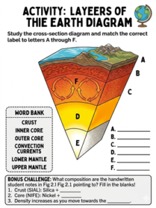
- A: CRUST
- B: UPPER MANTLE
- C: LOWER MANTLE
- D: OUTER CORE
- E: INNER CORE
- F: CONVECTION CURRENTS
Q 37 – Picture based Question:
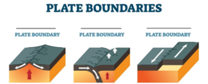
DIVERGENT, CONVERGENT, TRANSFORM
Q 38 – What is the difference between internal forces and external forces based on the text?
Internal forces operate inside the Earth (such as plate movements and volcanic activity) to create major structural changes in the crust. External forces operate outside the Earth (such as wind, water, and ice) to wear down the land through weathering and erosion.
Q 39 – Distinguish between the state of matter of the outer core and the inner core.
The outer core is in a liquid state, whereas the inner core is solid due to the immense pressure acting upon it.
Q 40 – What are tectonic plates according to the text?
Tectonic plates are large, rigid pieces of the earth’s crust that fit together like a puzzle to form the earth’s surface.
Q 41 – Name any four major tectonic plates.
Any four from the text can be named: Eurasian Plate, African Plate, Pacific Plate, Indo-Australian Plate, North American Plate, South American Plate, or Antarctic Plate.
Q 42 – Why is weathering considered important for agriculture and plant growth?
Weathering is the process by which rocks are broken down into smaller pieces in the same place where they are formed. In this process, rocks are not transported from one place to another.
Q 43 – Name the two primary ways plateaus are formed and provide one real-world example for each as mentioned in the text.
The two primary ways plateaus are formed are:
1. Volcanic Activity – Plateaus are formed when lava flows out of cracks in the Earth’s surface and spreads over large areas, then cools and hardens into flat elevated land.
Example:Deccan Plateau
2. Tectonic Movement (Uplift of Land) – Plateaus are formed when movements inside the Earth push large areas of land upward.
Example: Tibetan Plateau
Q 44 – List three primary reasons that lead to the formation of deserts.
Deserts form primarily due to atmospheric pressure patterns, mountainous topography, and geographical isolation from oceanic moisture.
1. Global High- Pressure Belts
- Hadley Cells: Cool air sinks near 30 degrees latitude.
- Warming Air: Sinking air compresses and warms.
- Evaporating Moisture: Warm air dissipates clouds and rain.
2. Rain Shadow Effects
- Mountain Barriers: Tall ranges block moisture-laden winds.
- Windward Rainfall: Air rises and drops rain on one side.
- Leeward Aridity: Dry air sinks on the opposite side.
3. Extreme Continentality
- Inland Distance: Regions lie deep inside massive continents.
- Depleted Moisture: Winds lose all water before reaching inland.
- Persistent Dryness: Land lacks nearby water vapor sources.
Q 45 – Describe the three types of plate movements based on plate boundaries, outlining the direction of movement and the main geological outcomes for each.
The three types of plate movements are:
- Divergent Movement: Plates move apart or away from each other. This results in the formation of new crust, volcanic activity, and rift valleys (e.g., the Mid-Atlantic Ridge).
- Convergent Movement: Plates move towards each other and collide. This process leads to the formation of mountains (like the Himalayas), earthquakes, and sometimes volcanic activity.
- Transform Movement: Plates slide past each other in opposite directions. This friction-heavy movement mainly results in strong earthquakes, as observed along the San Andreas Fault in the USA.
Q 46 – Detail the three main types of weathering explained in the text, highlighting how they distinctively affect rocks.
The three main types of weathering are:
- Physical or Mechanical Weathering: This is the mechanical breaking of rocks into smaller pieces without altering their chemical makeup. It is triggered by environmental factors like temperature changes, pressure release, and the freezing and thawing of water.
- Chemical Weathering: This breaks down rocks by altering their internal chemical composition. It takes place when water, oxygen, or acids react directly with the minerals inside the rocks.
- Biological Weathering: This process is driven by living things. For example, plant roots grow into existing cracks and physically pry rocks apart, while burrowing animals loosen up underground rocks and soil.
Q 47 – Differentiate between V-shaped valleys and U-shaped valleys based on their agents of erosion, location, and the specific natural processes that form them.
According to the textbook page, V-shaped valleys and U-shaped valleys differ fundamentally in their origins:
- V-shaped Valleys (River Valleys): These are formed by river erosion (running water) primarily in mountainous or hilly regions. In the upper course of a river, the water flows swiftly with immense kinetic energy. This creates powerful downward vertical erosion, which cuts deep into the solid bedrock over time. This continuous downward cutting results in a narrow valley characterized by steep sides.
- U-shaped Valleys (Glacial Valleys): These are formed by glacial erosion (moving masses of ice) in cold mountainous regions. Instead of cutting straight down swiftly, a massive glacier moves very slowly down a pre-existing river valley. As it moves, the heavy ice mass uses mechanical processes like abrasion and plucking to scrape, widen, and deepen the valley floor and walls. This extensive scraping transforms the originally narrow V-shaped valley into a broad U-shaped valley.