Question 1.
Answer the following questions briefly:
- Why do the plated move?
- What are exogenic and endogenic forces?
- What is erosion?
- How are flood plains formed?
- What are sand dunes?
- How are the beaches formed?
- What are the ox-bow lakes?
- Plates move due to the movement in the molten magma found in the interior of the earth.
- Exogenic Forces
- Exogenic forces are those forces that act on the surface of the earth and cause
changes on the surface of the earth.
Examples: Weathering, gradation, erosion, deposition.
- Exogenic forces are those forces that act on the surface of the earth and cause
- Endogenic Forces
- Endogenic forces are those forces that originate in the interior of the earth and
cause changes on the surface of the earth.
Examples: Volcanoes and Earthquakes.
- Endogenic forces are those forces that originate in the interior of the earth and
- Exogenic Forces
- Erosion
Erosion is the wearing away of the landscape by different agents like running water, glacier, wind, groundwater, and sea waves. - Flood plains are formed in the following manners:
- During rains, rivers overflow their banks.
- This leads to the flooding of the nearby areas.
- After the flood has receded, a layer of fine material and other material is deposited over the plain in the form of sediments.
- This leads to the formation of the flood plain.
- Sand Dunes
Sand dunes are heaps of sand deposited at a place by the wind’s action in the
desert areas. - Formation of Beaches
- Sea waves strike the coasts.
- They erode the coasts and carry the eroded material in the form of silt and other material.
- When they withdraw they deposit the silt and other material (sediments) along the shore, forming wide beaches.
- Ox-Bow Lakes
- When the meander loop is cut off from the main river, it forms a cut-off lake.
- Its shape is like an ox-bow.
- Hence, the cut-off lake is called an ox-bow lake.
Question 2. Tick the correct answer:
(i) Which is not an erosional feature of sea waves?
(a) Cliff
(b) Beach
(c) Sea cave.
(ii) The depositional feature of a glacier is
(a) Flood plain
(b) Beach
(c) Moraine.
(iii) Which is caused by the sudden movements of the Earth ?
(a) Volcano
(b) Folding
(c) Flood plain.
(iv) Mushroom rocks are found In
(a) Deserts
(b) River valleys
(c) Glaciers.
(v) Ox bow lakes are found In
(a) Glaciers
(b) River valleys
(c) Deserts.
(i) – (a), (ii) – (c), (iii)-(a) , (iv) -(a), (v)-(b)
Question 3.
Give reasons:
- Some rocks have the shape of a mushroom.
- Flood plains are very fertile.
- Sea caves are turned into stacks.
- Buddings collapse due to earthquakes.
Answer:
- Some rocks have the shape of a mushroom, because for the following reasons:
- When rocks fall in the course of running duststorms, the suspended particles of sand strike the lower portion of the rocks and erode them.
- The upper portions of the rocks remain unaffected/uneroded.
- In course of time, the rocks take up the shape of a mushroom.
- Flood plains are very fertile because of the following reasons:
- They are made of silt and other material brought by floods.
- Due to the spread of the new silt, the flood plains are fertile areas.
- Sea caves are turned into stacks because of the following reasons:
- The sea waves strike the coasts and erode the soft rocks. Hard rocks remain uneroded. This action results in the formation of sea caves.
- In course of time, the roofs of the caves also come down due to erosion and the arms/walls of the caves remain standing like pillars. • These pillars-like formations are termed stacks.
- Buildings collapse due to earthquakes because of the following reasons:
- Most buildings are not built/made earthquake-proof.
- When the earthquakes strike, the buildings are not capable of resisting the
vibrations of the earthquakes. - They tear apart due to shallow foundations, sub-standard interior material, and lack of adequate steel.
- They collapse and fall down like a pack of papers/cards.
Question 4.
Activity
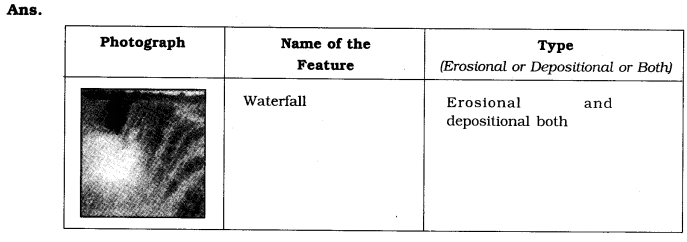
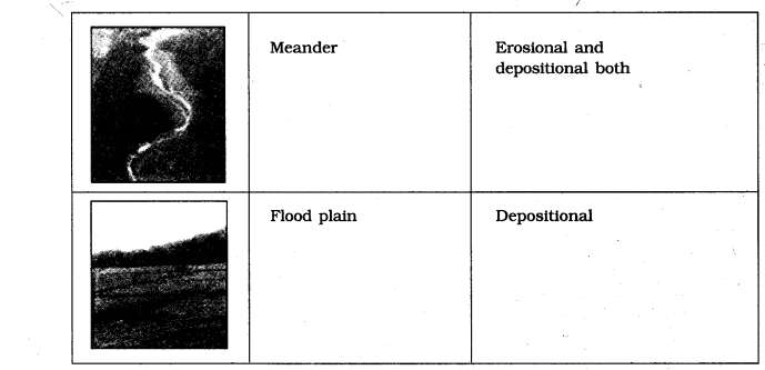
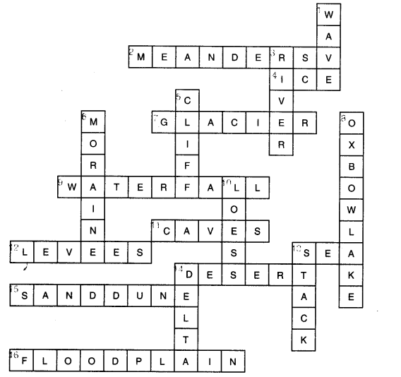
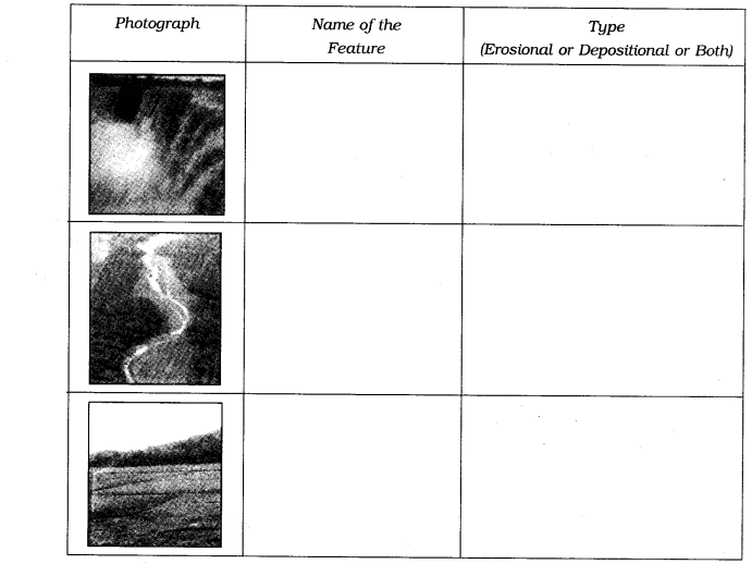
Observe the photographs given below. These are various features made by a river. Identify them and also tell whether they are erosional or depositional or landforms formed by both.
Question 5.
For fun.
Solve the crossword puzzle with the help of given clues.
Across
2. Loop like the bend of a river.
4. Solid form of water.
7. Moving mass of ice.
9. Sudden descent of water in the bed of a river.
11. Natural cavity on weak rocks formed by the action of waves.
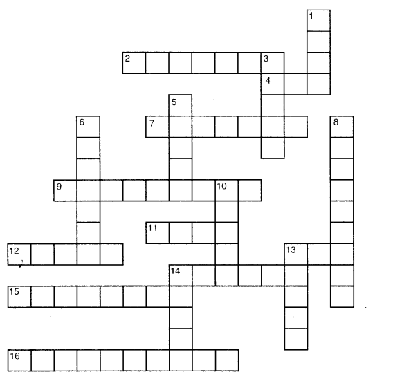
12. Embankment on a river that keeps it in its channel.
13. Large body of seawater.
14. Dry area where sand dunes are found.
15. Small hill of sand caused by the action of the wind.
16. Flat plain formed by river deposits during the time of the flood.
Down
1. Rise and fall of water caused by friction of the wind on the water surface.
3. Flow of water in a channel.
5. Steep perpendicular face of rock along a sea coast.
6. Debris of boulder and coarse material carried by a glacier.
8. Crescent-shaped lake formed by a meandering river.
10. Fine sand deposited by the action of the wind.
13. Isolated mass of rising steep rock near a coastline.
14. Alluvial tracts of land formed by the river deposits at the mouth of a river.
ACTIVITY
Question 6
Earthquake-A case study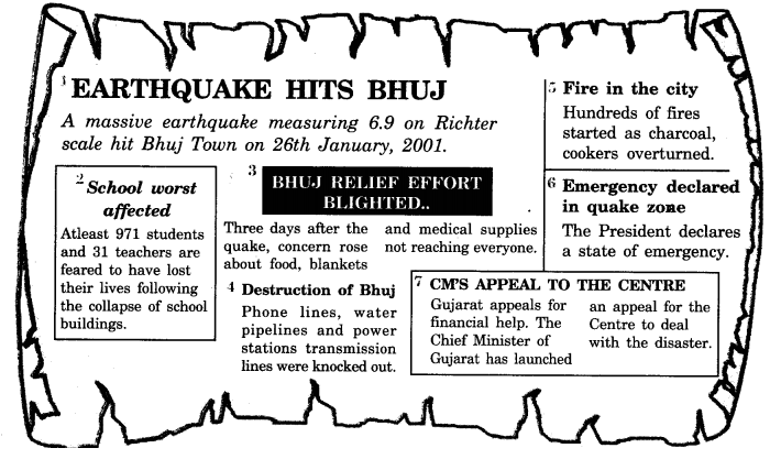
Activity
1. Read the ‘Earthquake – A case study’ given in the form of headlines that appeared in the newspapers after the quake. Arrange the events in the right sequence of their happening.
2. Imagine if a quake suddenly shook in the middle of the school day, where do you go for safety?
1. Sequence![]()
2. We would go for safety
- in the open
- under the gates
- would keep pillow or cushion on our heads.
Question 7.
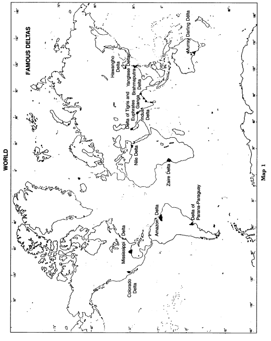
Find out the names of a few rivers of the world that form a delta?
Name of some rivers (See the Map):
- Mississippi—Missouri.
- Amazon.
- Parana—Paraguay.
- The Nile.
- Zaire.
- Tigris—Euphrates.
- Ganga—Brahmaputra.
- Indus.
- Hwang Ho.
- The Yangtze.
- Irrawaddy.
- Salwin.
- Murray—Darling.
Question 8. What do you know about the lithospheric plates?
The earth’s crust consists of several large and some small, rigid, irregularly— shaped plates, Le., slabs which cany continents and the ocean floor.
Question 9. How do the lithospheric plates move?
They move around very slowly, just a few millimeters each year.
Question 10. What is a volcano?
A volcano is a vent or opening in the earth’s crust through which molten material erupts suddenly.
Question 11. Define focus’ and ‘epicentre’.
The place in the crust where the movement starts is called the ‘focus’. The place on the surface above the focus is called the ‘epicentre’.
Question 12. Name the three types of earthquake waves.
- P waves or longitudinal waves
- S waves or transverse waves
- L wave or surface waves.
Question 13. What is a seismograph?
A seismograph is a machine which measures an earthquake.
Question 14. Name the scale on which the magnitude of the earthquake is measured.
Richter scale.
Question 15. Which earthquake is classified as a major earthquake?
An earthquake of 7.0 magnitude is classified as a major earthquake.
Question 16. Where is Victoria Falls located?
Victoria Falls is located on the borders of Zambia and Zimbabwe in Africa.
Question 17 . What is delta?
The collection of sediments from all the mouths forms a delta. It is a triangular-shaped landmass.
Question 18. Name some coastal landforms.
Sea caves, sea arches, stacks, and sea cliffs.
Question 19. How are glacial moraines formed?
The material carried by the glacier such as rocks big and small, sand and silt gets deposited. These deposits form glacial moraines.
Question 20. Name the two processes which wear away the landscape.
Weathering and erosion.
Question 21. What does the process of erosion and deposition create?
The process of erosion and deposition create different landforms on the surface of the earth.
Question 22. Name a few rivers of the world that form a delta?
Nile, Zaire, Ganga-Brahmaputra, Hwangotto, Murray-Darling, Amazon, etc.
Question 23. Mention the work of ice.
Glaciers are rivers of ice that erode the landscape by destroying soil and stones to expose the solid rock below. Glaciers carve out deep hollows. As the ice melts they get filled up with water and become beautiful lakes in the mountains. The material carried by the glacier such as rocks big and small, sand and silt gets deposited. These deposits form glacial moraines.
Question 24. What is an earthquake? What are some common earthquake prediction methods?
When the lithospheric plates move, the surface of the earth vibrates. The vibrations can travel all around the earth. These vibrations are called earthquakes. Some common earthquake prediction methods include studying animal behaviour, fish in the ponds get agitated, snakes come to the surface.
Question 25. Give an account of earthquake preparedness.
Earthquake is a natural calamity that we cannot stop. But we can minimize its impact if we are prepared beforehand.
During an earthquake, we should shift to some safe spot. We should hide under a kitchen counter, table, or desk against an inside comer or wall. We should stay away from fireplaces, areas around chimneys, windows that shelter including mirrors and picture frames. Moreover, we should spread awareness amongst our friends and family members.
Question 26. Explain the work of a river.
The running water in the river erodes the landscape. When the river tumbles at a steep angle over very hard rocks or down a deep valley side it forms a waterfall. While entering the plain the river twists and turns and forms large bends which are known as meanders. Due to continuous erosion and deposition along the sides of the meander, the ends of the meander loop come closer and closer.
In due course of time the meander loop cuts off from the river and forms a cut-off lake, which is also called an ox-bow lake. Sometimes, the river overflows its banks causing flood in the neighboring areas. As it floods, it deposits layers of fine soil and other material called sediments along its banks. As a result—a fertile floodplain is formed. The raised banks are called levees.
As the river approaches the sea, the speed of the flowing water decreases, and the river begins to break up into several streams known as distributaries. Then a time comes when the river becomes very slow and it begins to deposit its load. Each distributary forms its own mouth. The collection of sediments from all the mouths forms a delta, which is a triangular landmass.
Question 27. Give an account of the work of wind.
Wind is an active agent of erosion and deposition in the deserts. In deserts, we often notice rocks in the shape of a mushroom, known as mushroom rocks. Winds erode the lower section of the rock more than the upper part. Therefore, such rocks have a narrower base and a wider top. When the wind blows, it lifts and transports sand from one place to another.
When the wind stops blowing the sand falls and gets deposited in low hill-like structures. These are called sand dunes. When the grains are very fine and light, the wind can carry it over long distances. When such sand is deposited in a large area, it is called loess.
