Q 1 – Name the upper-level velocity winds blowing up to a height of 12 to 16 km. within the troposphere.
Ans. Jet streams.
Q 2 – Name the most common form of tropical storms.
Ans. Thunderstorms.
Q 3 – What is the local name of thunderstorms in West Bengal?
Ans. Kalbaishakhi.
Q 4 – The average annual rainfall in India.
Ans. 125 cm.
Q 5 – Which is the coldest place in India?
Ans. The coldest place in India is Drass(Kargil). Here the temperature drops upto-45°C.
Q 6 – Name the hottest place in India.
Ans. The Barmer (50°C) is the hottest place in Rajasthan.
Q 7 – Name the coastal states affected by tropical cyclones.
Ans. Tamil Nadu, Andhra Pradesh, West Bengal and Orissa.
Q 8 – What causes winter rainfall in south-east coast?
Ans. North-east monsoon causes winter rainfall in south-east coast.
Q 9 – In which part of India retreating monsoon causes rainfall?
Ans. Over the Coromandel coast.
Q 10 – What is October heat?
Ans. The oppressive weather due to high temperature and high humidity is known as October heat.
Q 11 – What is the local name of a thunderstorm in Assam and Bengal?
Ans. Assam-Bordoi chilla, Bengal – Kalbaishakhi.
Q 12 – What type of climate is found in India?
Ans. Tropical monsoon type climate.
Q 13 – Name the two factors which affect the Indian monsoon.
Ans. Pressure difference and the jet stream.
Q 14 – Name two main seasons of the Indian climate.
Ans.
1. South-west monsoon season.
2. North-east monsoon season.
Q 15 – Where do you find the polar type of climate in India?
Ans. In Jammu and Kashmir.
Q 16 – Name a long spell of abnormally hot weather.
Ans. Heatwave.
Q 17 – Which are the two places which receive the highest rainfall in India?
Ans. Mawsynram and Cherrapunji.
Q 18 – What are the two factors which are considered to be decisive in all the schemes of climatic classification?
Ans. Temperature, rainfall.
Q 19 – The criterion of classification on the basis of Thornthwaite’s scheme.
Ans. The Thomthwaite’s classification is based on the criterion of moisture index.
Q 20 – From which part of the India monsoon enters?’
Ans.
- the Arabian Sea,
- The Bay of Bengal
Q 21 – What is ITCZ?
Ans. The ITCZ means Inter-Tropical Convergence Zone.
Q 22 – Which major tropic India lies across?
Ans. Tropic of Cancer (23!/2°N latitude).
Q 23 – When there is cold weather in India, in which part the sun shines vertically?
Ans. The sun shines vertically over the Tropic of Caricom (23 1/2°S).
Q 24 – When does the south-west monsoon start retreating?
Ans. At the end of September.
Q 25 – What is the base of Koeppen’s scheme of climatic classification?
Ans. Koeppen’s classification is based on monthly values of temperature and precipitation.
Q 26 – Identify the four seasons based on Indian meteorology.
Ans. In India the year is divided into four seasons based on Indian meteorology.
- The cold weather season – begins from December to February.
- The hot weather season – begins from March to May.
- The south-west monsoon season – begins from June to September.
- There treating monsoon season – begins from October to November.
Q 27 – What are the coldest parts of India?
Ans. The coldest parts of India are the trans-Himalayan regions. Jammu Kashmir and Himachal Pradesh are the coldest states of India. The minimum temperature drops up to -40°C at Drass. These regions get snowfall during winter and temperature remains below freezing point.
Q 28 – What do you mean by ‘breaks’ in monsoon?
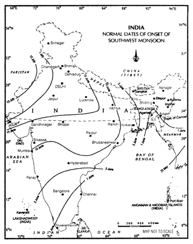
Ans. When the highly charged winds blow in south-west direction on the west coast, it advances rapidly over the west coast. The rain begins suddenly in the first week of June. The sudden onset of rain is termed as monsoon burst. The rainfall is heavily accompanied by thunder and lightning and appears as if a balloon of water has been burst. The sudden onset of monsoon is known as burst or breaking of monsoon.
Q 29 – What are the characteristics of western disturbances of the Indian climate?
Ans.
- The cyclones developed near the Mediterranean Sea are termed as western disturbances.
- They move towards India through Iran and Pakistan.
- They come under the influence of westerly jet stream which. brings them to the northern part of India in the winter season.
- They cause rain in the north-west part of the plain of India
Q 30 – What do you mean by ‘Loo’?
Ans. Loo’ is a hot and dry wind which blows from the west in the months of May and June in the northern part of India. It causes an increase in day temperature between 45°C and 50°C. It causes a harmful effect on the human body.
Q 31 – Name the four months in which India receives high rainfall and why.
Ans. India receives the bulk of rainfall in the months of June, July, August and September known as the rainy season.
It is because of the south-west monsoon winds, which are onshore during this period and easterly jet streams stress the tropical cyclone to India which causes heavy rainfall.
Q 32– Mention the formula used for calculation of the variability of rainfall.
Ans. The variability of rainfall is given by the formula Standard Deviation where C is known as the coefficient of variation.
Q 33 – Why Tamil Nadu gets more rain in winter than in summer?
Ans. Because Tamil Nadu lies on the Coromandel Coast on the eastern coastal plain. In summer, Tamil Nadu remains dry. But in winter, north-east monsoon picks up moisture and crosses the Bay of Bengal. These retreating monsoons are onshore winds causing rainfall in this area.
Q 34 – Why Mawsynram and Cherrapunji get very high rainfall?
Ans. Mawsynram receives the highest amount of rainfall in the world in the rainy season because it is surrounded by the North-east hills of India, mainly Khasi, Garo, Jaintia in Meghalaya plateau is funnel-shaped. The Bay of Bengal branch of the south-west monsoon is enclosed by these hills resulting in the heaviest amount of rains.
Q 35 – Give the main characteristics of the monsoons rains
Ans.
- . The beginning of the rains is sometimes delayed over the whole or a part of the country.
- There are prolonged breaks of rains in July or August.
- Sometimes the rain ends earlier than usual time causing great damage to standing crops.
- The summer rainfall comes in heavy, leading to soil erosion.
Q 36 – What do you understand by ‘Mango showers’?
Ans. Mango showers’ are actually premonsoon showers experienced towards the summer monsoon. It is common in Kerala and coastal areas of Karnataka in March and April. It helps in the ripening of mangoes. Therefore, locally it is known as Mango-showers.
Q 37 – What is the average amount of rainfall over the plains of India?
Ans. The plain is divided into three zones to study the average rainfall.
- The plains of Bihar, Bengal and eastem U.P.-rainfall is 100-200cm.
- The plains of central and western U.P. – rainfall is 60-100 cm.
- Plains of Haryana, Punjab – rainfall is 40-60 cm. annually.
Q 38 – What is the Inter-Tropical Convergence Zone (ITCZ)? How does it attract south monsoon? What are the important factors which influence the mechanism of Indian weather?
Ans. ITCZ is the zone near the equator from where the north-east trade winds and the south-east trade winds meet each other. It changes its position with the effect of the vertical rays of the sun. It is near the Tropic of Cancer in the north in summer season and near the Tropic of Capricorn in the south in the winter season at about 25°N, as a result of which the south-east trade winds cross over the equator and enter in India as the south-west monsoon.
Factors influencing the mechanism of Indian weather-
- Surface distribution of pressure and winds include monsoon, location of low and high pressure.
- Upper air circulation which includes global weather conditions like air masses and the jet stream.
- Atmospheric disturbances like western cyclones and tropical cyclones cause rainfall.
These are the factors which affect the Indian weather.
Q 39 – Rainfall in India is orographic in nature. Describe the distribution of rainfall and the effect of relief on its distribution.
Ans. The orographic nature of rainfall plays an important role in the distribution of rainfall in India. The rainfall is determined by the situation of the mountains. In India, it is called relief rainfall. It affects the distribution of rainfall in the following manner:
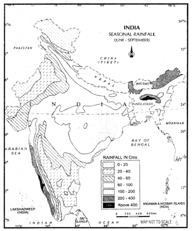
- Western-coastal plains receive heavy rainfall due to the Western Ghats, more than 300 cm. but Deccan plateau that lies in the rain shadow area receives only 60 cm. rainfall.
- Low rainfall in the rain shadow area of the Western Ghats (less than 60 cm.).
- Due to funnel-shaped hills, heavy rainfall in Meghalaya (more than 1000 cm.).
- Low rainfall in Rajasthan due to the direction of the Aravali range. It lies parallel to the south-west monsoon winds. So, Rajasthan remains dry.
- Effect of Himalayan ranges on the direction of the monsoon. It does not allow the winds to cross. Hence the Ganga plain receives rainfall but it decreases westwards

Fig. 4.8: India: Seasonal Rainfall (June-September)

Fig. 4.9: India: Normal Dates of Onset of the Southwest Monsoon
Q 40 – What is EI-Nino? How is it related to Indian monsoon?
Ans. El-Nino is used for forecasting long-range of monsoon rainfall. The system involves the ocean and atmospheric phenomena with the appearance of warm winds off the coast of Peru in the Eastern Pacific which affect the weather. EI-Nino is a complex weather system. It appears once every 5 to 10 years bringing drought, floods and other weather extremes to different parts of the world.
Q 41 –Define ‘drought’ and its various types.
Ans, Drought is a condition in which the amount of water needed for evapotranspiration exceeds the amount of water available for precipitation and soil.
Droughts are of three types:
- permanent,
- seasonal,
- contingent.
Permanent drought is characterised by the arid climate in which vegetation is sparse and hardy, fully adapted to water shortage.
Seasonal drought is found in dry and rainy seasons. Most of the parts of India suffer from this kind of drought.
Contingent drought is irregular with variable rainfall and occurs in any season but frequently in sub-humid climates.
Q 42 – What is global warming? Give reasons.
Ans. The climate of the world has changed in the past and is changing at present. Several natural and artificial factors are responsible for this change. Due to global warming, the polar ice caps and mountain glaciers would melt and the amount of water in oceans would increase.
There are following reasons for global warming:
- The temperature of the world is increasing nowadays.
- Carbon dioxide is the major source of global warming. This gas is released to the atmosphere by burning of fossil fuel.
- Other gases like methane, chlorofluorocarbons, ozone and nitrous oxide which are present in much smaller concentrations in the atmosphere, together with carbon dioxide are known as greenhouse gases. These gases are contributing to global warming.
- Rapid industrialization and technological changes, the revolution in agriculture and transport sectors has resulted in large supplies of carbon dioxide and methane which cause global warming.