Q 1 – India has a land boundary of about-
(a) 15,860 km.
(b) 15,250 km.
(c) 15,680 km.
(d) 15,200 km
Ans 1 – (d) 15,200 km
Q 2 – The Tropic of Cancer does not pass through-
(a) Rajasthan
(b) Chhattisgarh
(c) Orissa
(d) Tripura
Ans 2 – (c) Orissa
Q 3 – The capital of Mizoram is-
(a) Imphal
(b) Kohima
(c) Agartala
(d) Aizwal
Ans 3 – (d) Aizwal
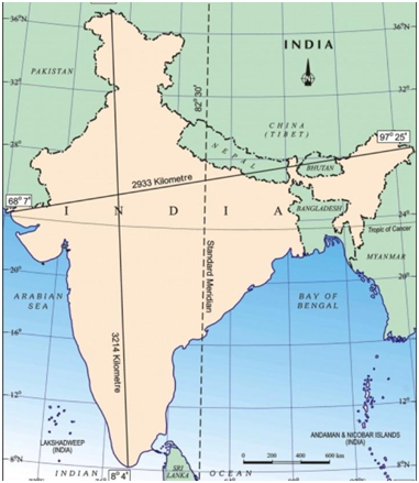
Q 4 – The easternmost longitude of India is-
(a) 97° 25’ E
(b) 68° 7’ E
(c) 77° 6’ E
(d) 82° 32’ E
Ans 4 – (a) 97° 25’ E
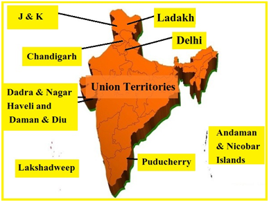
Q 5 – If you intend to visit the Island Kavaratti during your Summer Vacations, which one of the following Union Territory of India will you be going to-
(a) Pondicherry
(b) Lakshadweep
(c) Andaman and Nicobar
(d) Diu and Daman
Ans 5 – (b) Lakshadweep
Q 6 – Match the following
| Column A | Column B |
| (a) Peninsular | A. a piece of land surrounded by water on all sided |
| (b) Island | B. Time determined by the mid-day Sun |
| (c) Local Time | C. Time taken for the whole country |
| (d) Standard Time | D. a narrow stretch of sea linking two large area |
| (e) Strait | E. a piece of land surrounded by water on three sides |
Ans 6 –
| Column A | Column B |
| (a) Peninsular | E. a piece of land surrounded by water on three sides |
| (b) Island | A. a piece of land surrounded by water on all sided |
| (c) Local Time | B. Time determined by the mid-day Sun |
| (d) Standard Time | C. Time taken for the whole country |
| (e) Strait | D. a narrow stretch of sea linking two large area |
Q 7 – What is the time difference between the westernmost and the easternmost tips of India ?
Ans 7 – 2 Hours
Q 8 – What is the north-south and the east-west distance of India ?
Ans 8 – North to South 3214 kms and West to east 2933 kms
Q 9 – In which year Suez Canal was opened?
Ans 9 – Suez Canal opened up in 1869.
Q 10 – Name the place said to be situated on the three seas . Name the seas also.
Ans 10 – The place situated on the confluence of three seas is also known as ‘Triveni Sangam’. Kanyakumari is surrounded by the seas on three sides like – Bay of Bengal, Indian Ocean, and Arabian Sea, making it a mesmerizing beauty of earth.
Q 11 – What percent of the world’s land area is with India ?
Ans 11 – 2.42 percent
Q 12 – Why has India selected a Standard Meridian of India with an odd value of 82o30′ ?
Ans 12 – (i) Because it is divisible by 7, a standard adopted by almost all the countries of the world.
(ii) It lies almost in the middle of India, and as such, it suits us the most.
Q 13 – Why is India called a subcontinent ?
Ans 13 – India is called a subcontinent because :
- It is a big landmass. This stands out as a distinct geographical unit from the rest of the continent.
- It is separated by natural features like mountains and rivers.
- India is also separated from rest of the continent by the mighty Himalayas.
Q 14 – Why is the north-south extent of India larger than east-west extent even though the latitudinal and longitudinal extent in degrees is of the same value?
Ans 14 – This is because the distance between two latitudes is always 111 km i.e. always same whereas between two longitudes, it is the maximum at the equator and decreases towards the poles.
Q 15 – Name eight Indian states through which the Tropic of Cancer passes.
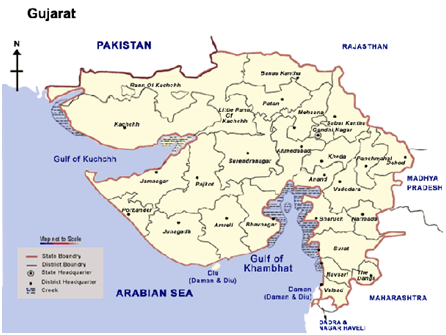
Ans 15 – Tropic of Cancer passes through 8 Indian states including Gujarat, Rajasthan, Madhya Pradesh, Chhattisgarh, Jharkhand, West Bengal, Tripura and Mizoram.
Q 16 – What is the importance of Suez Canal for India? Justify the naming of Indian Ocean after India.
Ans 16 – Suez Canal is in Egypt and it connects port Said on the Mediterranean sea to the Indian ocean via the Egyptian city of Suez on the Red Sea. Since the opening of the Suez Canal in 1869 India’s distance from Europe has been reduced by 7000 kms The Indian ocean is named after India because: India holds a central location which is at the head of the Indian Ocean. India in ancient times was an important location in the Indian Ocean which connected Europe with countries of Southeast Asia.
Q 17 – What is latitude? What is the latitudinal extent of India?
Ans 17 –
- The position of a place, measured in degrees north or south of the Equator. It is mostly calculated
because of angular distance of a place north-south of the equator, - The main land of India extends between latitudes 8°4′ N and 37°6′ N.
- The latitudinal extension shows that India is located in the Northern Hemisphere.
Q 18 – Explain why Ahmedabad and Kolkata are able to see the noon sun exactly overhead in a year but not Delhi.
Ans 18 – The sun’s apparent movement towards north and south of the equator is within two tropics.
(a) All the places located within the tropics have overhead sun twice a year.
(b) Both Ahmedabad and Kolkata lie to the south of the Tropic of Cancer. That is why these two stations see the noon sun overhead twice a year.
(c) Delhi is located at 29°N latitude much to the north of Tropic of Cancer.
(d) The sun’s rays are near overhead in sub-tropical zone. It will never see noon sun overhead, at anytime of the year.
Q 19 – Which ocean is named after India ? Give two reasons as to why it was named after India.
Ans 19 – The Indian Ocean is named after India. India is the only country which has the credit of an ocean named after it. The Arabian Sea and the Bay of Bengal, extensions of the Indian Ocean, lie to the west and east of Indian Peninsula, and the Indian Ocean lies to its south. No other country has a long coastline on the Indian Ocean as India. The central location of India at the head of the Indian Ocean has provided India a strategic
location of great significance along the trans Indian Ocean routes. It is India’s eminent position in the Indian Ocean which justifies the naming of the ocean after India.
Q 20 – Identify the following with the help of map reading.
- The countries constituting the Indian Subcontinent .
- The southernmost latitude of the Indian Mainland in degrees .
- The state with the longest coastline .
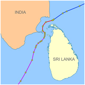
- The strait separating Sri Lanka from India.
- The Union Territories of India.
Ans 20 – Identify the following with the help of map reading.
a) The countries constituting the Indian Subcontinent .
b) The southernmost latitude of the Indian Mainland in degrees
c) The state with the longest coastline.
d) The strait separating Sri Lanka from India
e) The Union Territories of India
Q 21 – Explain how the geographical location has helped India in attaining an important place in the world market.
Ans 21 – (i) Due to its central location at the head of the Indian Ocean, countries of East Africa, West Asia, South and South-East Asia and East Asia could be reached through sea routes.
(ii) Unlike landlocked countries (surrounded by land on all sides), it has an easy access to the outside world. The ocean routes from East and South-East Asia and Australia to Africa and Europe pass through the Indian Ocean.
(iii) India is connected with Europe, North America and South America through both the routes- the Cape of Good Hope and the Suez Canal.(iv) India can also reach Canada and USA through the strait of Malacca after crossing the Pacific Ocean.
Q 22 – What is the latitudinal extent of India? How is the longitudinal spread in India advantageous to her?
Ans 22 – The latitudinal extent of India lies between 8°4’ N and 37°6’ N. This means that the longitudinal expanse is about 30° from west to east.
The advantages of longitudinal spread are :
(a) It influences the duration of the day and night as one moves from South to North.
(b) It also helps to take advantage of the Indian Ocean, the Arabian Sea on the west and the Bay of Bengal on its east for sea movements.